Northeast Kingdom VT Hikes
Jay Peak Northern VT Hiking Trails
 If your outdoor interests are piqued by the prospect of hiking a diverse trail system over varied terrain, encountering panoramic vistas, breathing fresh mountain air, splashing in brisk alpine streams, and resting in forests abundant with wildlife, then you have found your outdoor paradise in the mountains and woodlands of Northeast Kingdom Vermont. Yes, Vermont is the home of Kingdom Trails, a wonderful place to hike and explore. Please share your Vermont hikes and comments. To feature your VT business, contact us. Safe and happy hiking from Vermont Living Magazine.
Jay Peak Vermont Hikes & Kingdom Trails

Phineas Swann Bed & Breakfast Inn, 195 Main Street, Montgomery Center, VT 05471 | 802-326-4306
The Phineas Swann Bed & Breakfast is New England's most romantic and pet-friendly getaway. Located just 7 miles from Jay Peak Resort, the Phineas Swann offers year-round recreational and vacation options, including skiing, hiking, cycling, mountain biking, cross-country skiing, snowmobiling, leaf-viewing, and even swimming at Jay Peak's indoor water park.
Visit Phineas Swann Bed & Breakfast

The Wildflower Inn, 2059 Darling Hill Road, Lyndonville, VT 05851 | 802-626-8310
Trailside Lodging in the Northeast Kingdom of Vermont. Your next great adventure awaits at The Wildflower. A four-season destination property for the best in outdoor recreation and Vermont experiences. With our 25-room Inn, full-service restaurant, pub, Village Sport bike shop (with rentals) and KCE guide company right on the property, you will have everything you need to make the most of your Vermont visit.
Visit The Wildflower Inn - Lyndonville, VT

Jay Peak Resort, Hotel Jay, 830 Jay Peak Road, North Troy, VT 05859
Welcome to Jay Peak - The Top of Vermont! Experience mountain thrills by day and cozy up with family fun by night around the firepit. The Jay Peak Resort features a Pump House Indoor Waterpark, Jay Peak Resort Golf Course, Flyer Express Quad. On-site spa has 2 treatment rooms. Find current specials and rates below.
Visit Hotel Jay, Jay Peak - North Troy, VT
 Herbert & Evelyn Hawkes Trail (Mount Hor)
Willoughby State Forest
Barton, Vermont
Total Distance: 3.5 Miles
Hiking Time: 3 Hours
Vertical Rise: 1050 ft.
The trail parking area is accessed through the South Trail (Mt. Pisgah) trailhead parking area on the West side of Route 5A at the South end of Lake Willoughby. On the right side of the South Trail the Mt. Pisgah parking area is a gravel road you must follow to the Mt. Hor trailhead, bearing right at the fork and continuing to a smaller parking area approximately 1.8 miles from the highway.
Just past the parking area on the right is the blue-blazed trail climbing the bank and following an old road. Watch carefully for very few blazes marked on small trees. Follow along the hillside walk to the West Branch Trail junction at 0.7 miles leading to the wooded summit of Mount Hor, and just beyond to an overlook. Returning to the main trail, follow the East Branch Trail along the ridge line to another overlook and junction with East Lookout Trail on the right, and then finally to the North Lookout with mountain and lake views. Return to the summit and follow the same trials back to the parking area.
Jay Peak Trail (Jay Peak)
Jay State Forest
Jay, Vermont
Total Distance: 3.5 Miles
Hiking Time: 4 Hours
Vertical Rise: 1680 ft.
Rating: Moderate
The trailhead parking area is on the South side of Route 242, approximately 1.4 miles West of the Jay Peak Ski Area and 6.6 miles East of Montgomery Center. Follow the white-blazed Long Trail, Northward up the bank opposite the parking area. The small lean-to you see is the Atlas Valley Shelter, and is not designed for over-night use. Continue past the South end of a loop trail to Jay Camp (a frame cabin with bunk space), going straight at the junction, climbing gradually and then more steeply through forest past the North end of the Jay Camp spur trail. At the 1.0 mile mark turn left over some steep ledges, then left again at 1.2 miles to a steep climb emerging on a ski trail. Continue directly across the ski trail and climb the steep rocks to the summit and the upper station of the Jay Peak Tramway. Your return hike follows the same trials back to the parking area.
South Trail at Lake Willoughby (Mount Pisgah)
Willoughby State Forest
Barton, Vermont
Total Distance: 2.5 Miles
Hiking Time: 3 Hours
Vertical Rise: 1590 ft.
Rating: Moderate
The trail parking area is on the West side of Route 5A at the South end of Lake Willoughby, with the trailhead marked by a sign on the opposite side of the road. Follow the blue-blazes over the road embankment turning left across a wooden bridge to an old road that bears right away from a pond. After a sharp left you follow the ridge uphill to the Pulpit Rock sign at the 0.9 mile mark. This spur trail leads to a rock overhang 650 feet above the lake. Returning to the main trail, your ascent continues along the ridge bearing right away from the lake. At 1.9 miles another spur trail to Upper Overlook offers spectacular lake and mountain views. Your return hike follows the same trails back to the parking area.
Mount Monadnock, VT (3,140 ft. elevation)
Located 1/2 mile west of Colebrook, NH this mountain dominates the landscape in the Colebrook area. The trail is located by taking Bridge St. off Main Street in Colebrook, cross the river into Vermont then turn immediately after crossing the bridge and enter the sand and gravel pit on the left. The trail begins at the sand pit and is marked by sings. The trial passes through mixed hardwood and softwood forest, and at the top of the mountain there is a fire tower. At the top of the tower the view is spectacular in every direction. Canada to the north and Maine and New Hampshire to the east. A moderate hike.
Brousseau Mountain – Averill, VT (2,714 ft. elevation)
To find this trail head travel West on Vermont Route 114 in Averill, Vermont 1.5 miles from Lake View Store. Take a left on Mountain Road. 1.3 miles down Mountain Road there is a dead end gate. Turn your car around so you don’t block anything. About 35 minutes to the top of this mountain on a will-marked trail. At this point there is no view. Take another trail to the right to the lookout point, about two minutes away. This vantage point provides a wide panorama view of the White and Green Mountain ranges.
Averill Mountain – Averill, VT
Find this by first getting to the Averill Lake View Store. Just one-half mile from the store you will see a small white sing for Averill Mountain. The mountain has a gradual ascent with verical rise of 550 feet from the trail’s starting point. The trails is ery well marked and upon reaching the summit, you can see Table Rock in Dixville, NH, Mount Washington, and Jay Peak to the west.
Gore Mountain – Averill, VT
To find the trail to the top of Gore Mountain take Vermont Route 114 south from the village of Norton for 9.9 miles. Look for Lake Station Road at the north end of Norton Pond and pull off between that and Devost Road. The trail enters through a small opening on the east side of the road. The hike includes a series of beaver meadows, crossing several brooks and through the edge of an expansive logged area. From the summit there are views of the Nulhegan Basin a popular bird and wildlife viewing area. Length of the trail to the top of Gore Mountain is 3.8 miles.
inns | hotels | resorts | rentals | attractions | dining | real estate
SUGGESTED NORTHEAST KINGDOM VT LODGING Visit NEK VT Vacation Specials. Browse Northeast VT vacation rentals, inns, resorts, and pet-friendly lodging availabilities below.Vermont Hiking Trails

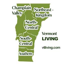
Explore Vermont hiking trails in every region. Champlain Valley, Northeast Kingdom, North-Central, South-Central and Southern Vermont.
Champlain Valley VT Hikes & Trails
Burlington, Middlebury, St. Albans, the Islands of NW Vermont
North Central VT Hikes & Trails
Montpelier, Barre, Randolph, Waterbury, Stowe, Mad River Valley
Northeast Kingdom VT Hikes & Trails
St. Johnsbury, Newport, Barton, Lyndonville, Burke, Jay, Island Pond
South Central VT Hikes & Trails
Rutland, White River Jct., Woodstock, Quechee, Brandon, Killington, Ludlow, Weston, Chester
Southern VT Hikes & Trails
Bennington, Brattleboro, Manchester, Arlington, Newfane, Mt. Snow area
Hiking Tips | Wiessner Woods Stowe Hikes
Vermont Products | Visit VT Towns | FWM 24/7 Shopping
Country Weddings | New England Recipes
VT Inns | Red Sox Gifts | Travel Destinations
New England Living Magazine
Fitness and Sports Products On Sale Now
Join Amazon Prime - Watch Thousands of Movies & TV Shows Anytime - Start Free Trial Now
Free World Mall
Country Weddings | Vermont Products | New England


