South Central Vermont Hikes
Pico Killington Woodstock VT Hiking Trails
 Find hikes in Woodstock, Brandon, Ascutney and Killington. If your outdoor interests are piqued by the prospect of hiking a diverse trail system over varied terrain, encountering panoramic vistas, breathing fresh mountain air, splashing in brisk alpine streams, and resting in forests abundant with wildlife, then you have found your outdoor paradise in the mountains and woodlands of South Central Vermont. Please share your Vermont hiking comments.
South Central VT Hikes

The Vermont Inn, 78 Cream Hill Road, Mendon, VT 05701 | 802-775-0708
The Quintessential New England Country Inn. The Vermont Inn is located in the Green Mountains, halfway between Rutland and Killington. The Vermont Inn has been welcoming guests since the 1940s. Originally built as a farmhouse in the 1840s, the inn now features 15 individually decorated guest rooms and suites. Sensational Vermont Breakfast, Pet Friendly rooms available. Seasonal outdoor pool. Inquire about small weddings, family gatherings, or special requests.
Visit The Vermont Inn - Mendon, VT

Killington Grand Hotel, 228 E Mountain Rd, Killington, VT 05751
Ski Killington! Hit the slopes in style or relax with a soothing massage. Ski the Beast, golf, hike, bike, or just enjoy Vermont. Unwind by the firepit or explore nearby attractions. Find current specials and rates below.
Visit Killington Grand Hotel - Killington, VT

Okemo Resort, Jackson Gore Condo Rental, Ludlow, VT
Welcome to your stunning 1-bedroom condo for 4, where beautiful and convenient living awaits. Located close to amenities, shops and attractions, you'll have everything you need right at your fingertips. Access top Okemo resort amenities and more, to make your stay truly unforgettable! Check current rates and availabilities below.
Visit Okemo Resort, Jackson Gore, Ludlow, VT
 Weathersfield Trail (Mt. Ascutney) – Ascutney, Vermont
Total Distance: 6.0 Miles
Hiking Time: 4.5 Hours
Vertical Rise: 2250 ft.
Rating: Strenuous
From exit 8 off I-91 drive 3.3 miles to a right turn (North) onto Cascade Falls Road. Bear left at the fork to a right turn at 3.6 miles. Follow up a short steep hill to the Ascutney State Park parking area. From the information board, take the blue-blazed Weathersfield Trail which ascends log stairs as it enters the woods. The trail winds, rises, and falls over varied terrain to the 1.3 mile mark where it levels slightly to cross the valley and meets an old roadway. This is the white-blazed Old Weathersfield Trail, which you follow past Gus’s Lookout and a trail to the left that leads to the West Peak. Continue straight from this junction to the antennae-covered summit at 2.9 miles. Return to the junction and follow the same trail back to the parking area.
Brownsville Trail (Mt. Ascutney), Windsor, Vermont
Total Distance: 6.4 Miles
Hiking Time: 5.0 Hours
Vertical Rise: 2400 ft.
Rating: Moderate
In Ascutney State Park
From Windsor follow Route 44 toward Brownsville. The trailhead parking area is located on the South side of Rt. 44 approximately 2 miles past the I-91 overpass. The trial is well-marked and passes an old granite quarry with stone hut remains, and a short spur trail offering good Northern views. A moderate grade extends to the lookout tower and the grassy summit of the North Peak with fine views of the valley and distant mountain range. Your return hike follows the same trail back to the parking area.
The Great Cliff & Mount Horrid Overlook Trial (Mt. Horrid) – Brandon, Vermont
Total Distance: 1.4 Miles
Hiking Time: 1 Hour
Vertical Rise: 620 ft.
Rating: Moderate
In the Green Mountain National Forest
Follow Route 73 to the top of Brandon Gap with trailhead parking on the South side of the road. Cross the highway and climb the bank heading North on the white-blazed Long Trail and follow 0.6 mile to the Great Cliff Overlook. Past the sign the trail steeply ascends on log steps to a ridge, and soon becomes much rockier and steeper as it leads to a blue-blazed trail on your right to the Great Cliff of the 2800 foot Mount Horrid Overlook. Your return hike follows the same trail back to the parking area.
Pico Peak Trail (Pico Peak) – Killington, Vermont
Total Distance: 5.4 Miles
Hiking Time: 3.5 Hours
Vertical Rise: 1800 ft.
Rating: Moderate
Between the Green Mountain National Forest and Coolidge State Forest
Follow Route 4 to the top of Sherburn Pass, approximately 5 miles West of Killington or 9 miles East of Rutland. Trailhead parking is on the South side of the road opposite the Inn at Long Rail. You will find the trail directly behind the parking area heading South past the remains of two buildings to a registration box and the white-blazed Long Trail. The trail follows a moderate grade to a ridge and spur trial at 0.6 mile mark where it eases a bit to the 1.1 mile mark and becomes steeper, traversing a ski trail to the 2.1 mile mark before returning to the woods and rockier terrain to the 2.5 mile mark at Pico Camp with bunk space for 12. Behind the Camp is the blue-blazed Pico Peak Trail which is very steep and bears left twice to cross a work road and another ski trail before ending at the 3957 foot summit at 2.9 miles. Your return hike follows the same trail back to the parking area.
Precipice Trail (Mt. Tom) – Woodstock, Vermont
Total Distance: 2.5 Miles
Hiking Time: 2.0 Hours
Vertical Rise: 1340 ft.
Rating: Moderate-Difficult
From Woodstock town center, cross the Mountain Avenue covered bridge past River Street following around a left curve to the prominent rock wall where you turn left up a paved path that leads to the trail head at Faulkner Park. The trail leads to the 1,340 foot summit overlooking the village of Woodstock, the Billings Farm and the Ottauquechee River. Your return hike follows the same trail back to the parking area.
Mount Peg Trail (Mt. Peg) – Woodstock, Vermont
Total Distance: 2.0 Miles
Hiking Time: 2.0 Hours
Vertical Rise: 1200 ft.
Rating: Moderate-Difficult
From the Woodstock Village Green, take Cross Street to High Street and turn right going over the bridge where you turn right again onto Golf Avenue. A sign on the left marks the trial head consisting of a system of groomed ski trails leading from an open field on the northern hill to benches where you can view Mount Tom across the valley and take in some of the best views of Woodstock Village. Your return hike follows the same trail back to the parking area.
HARTNESS PARK (Hilliard Hill) – Springfield, Vermont
Hiking Time: 2.0 Hours
Rating: Moderate-Difficult
Hartness Park was the training area for the Springfield High School Ski Team from the 1950’s until the 1980’s. The old ski jumps have been abandoned and overgrown. The first 40 meter jump was dedicated to John Hillard and named “Hilliard Hill” in a dedication ceremony in March of 1962. The property was given to the Town of Springfield by Governor James Hartness in 1934 with the intention that the Park should be maintained by the Town and its citizens for public use a a picnic and recreation area.Walking Distance: The Park is approximately 1/2 mile in length. Most loops around the upper or lower sections are about 1.25 miles in length. Parking: The Woodbury Road and Water Tower on Summer Street entrances each have room for 2 cars; there is also room for several cars on the end of the cud-de-sac on Dell Road. Parking is available at the Springfield Family Center after 5:00pm and on weekends.
inns | hotels | resorts | rentals | dining | real estate
SUGGESTED WOODSTOCK VT LODGING Visit Woodstock Vacation Specials. Browse Woodstock VT vacation rentals, inns, resorts, and pet-friendly lodging availabilities below.Vermont Hiking Trails

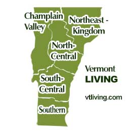
Explore Vermont hiking trails in every region. Champlain Valley, Northeast Kingdom, North-Central, South-Central and Southern Vermont.
Champlain Valley VT Hikes & Trails
Burlington, Middlebury, St. Albans, the Islands of NW Vermont
North Central VT Hikes & Trails
Montpelier, Barre, Randolph, Waterbury, Stowe, Mad River Valley
Northeast Kingdom VT Hikes & Trails
St. Johnsbury, Newport, Barton, Lyndonville, Burke, Jay, Island Pond
South Central VT Hikes & Trails
Rutland, White River Jct., Woodstock, Quechee, Brandon, Killington, Ludlow, Weston, Chester
Southern VT Hikes & Trails
Bennington, Brattleboro, Manchester, Arlington, Newfane, Mt. Snow area
Hiking Tips | Wiessner Woods Stowe Hikes
Vermont Products | Visit VT Towns | FWM 24/7 Shopping
Country Weddings | New England Recipes
VT Inns | Red Sox Gifts | Travel Destinations
New England Living Magazine
Fitness and Sports Products On Sale Now
Join Amazon Prime - Watch Thousands of Movies & TV Shows Anytime - Start Free Trial Now
Free World Mall
Country Weddings | Vermont Products | New England


